Florida & North Carolina Parcel Maps and Property Data.
Access accurate cadastral maps, parcel boundaries, ownership records, sales history, zoning, acreage, reports, CSV exports, KML files, and non-legal site plans — on web and mobile.
Search property lines and ownership data across all Florida and North Carolina counties for multi-state land and property research.
Try EarthPlat® free for seven days.
Free 7-Day Trial
What Is EarthPlat?
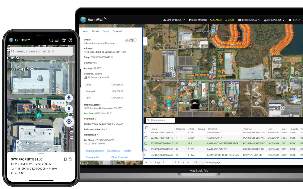
EarthPlat brings parcel boundaries and property research into one easy interface. Instead of jumping between county sites, you can search and explore parcels on an interactive map and quickly access key property details. See some screenshots
Parcel Boundary Maps
Florida & North Carolina parcel lines and property boundaries on a fast, interactive GIS map. Zoom seamlessly from county level down to individual lots explore real-time parcel data. Perfect for property research and land evaluation.
Ownership & Details
Instantly look up property ownership information and key parcel attributes used in real estate research. Access owner names, land use data, acreage, and commonly referenced county property details to support investment & development planning.
Export Parcel Data
Organize parcels into custom folders, export individual or grouped parcels to CSV and KML, and create printable or PDF general reference site plans (non-legal) using Roadmap or Hybrid view.
Florida & North Carolina Investor Research Tools
If you’re a Florida or North Carolina real estate investor (including folks coming from BiggerPockets discussions), EarthPlat helps you research parcels faster with property lines, owner lookup, and saved parcels.
- BiggerPockets Miami property research — property lines, owner lookup, and parcel maps for Miami-Dade County.
- BiggerPockets Tampa land investing tools — parcel research and land investor workflows for the Tampa area.
- BiggerPockets Orlando parcel search — find parcels faster in Central Florida with EarthPlat.
Frequently Asked Questions
Can I find property ownership in EarthPlat?
Yes — EarthPlat helps you look up ownership information alongside parcel boundaries and key parcel details. Data availability may vary by county.
Can I save parcels in EarthPlat?
Yes! EarthPlat allows you to save parcels into groups, choose a color for each group, and easily load or export them. This makes comparing multiple parcel groups on the map simple and visually clear.
Can I export parcel data from EarthPlat?
Yes! EarthPlat allows you to export parcel data to CSV or KML from selected parcels or saved groups. This makes it easy to use your data in spreadsheets, GIS software, or other mapping tools.
Does EarthPlat cover all of Florida & North Carolina?
EarthPlat supports all counties in states we support, making it easy to research parcels statewide.
Why only Florida & North Carolina?
For now, EarthPlat covers Florida & North Carolina only. By focusing on a single state(script, we’re able to deliver regularly updated parcel data sourced directly from county property appraiser offices—so you’re working with current, dependable information.
Do you plan to expand to other states?
Yes. We’re actively implementing the same frequent data-update methods used in Florida for additional states. We’re currently working on California, Montana, Utah, and several others. As new states are added, they will be included in your existing subscription at no additional cost.
Serving the following states: Florida and Florida Counties, North Carolina | Cadastral Map
© 2026 TMAIDA INC. EarthPlat® is a registered trademark of TMAIDA INC. All rights reserved.